


Gjør som tusenvis av andre bokelskere
Abonner på vårt nyhetsbrev og få rabatter og inspirasjon til din neste leseopplevelse.
Ved å abonnere godtar du vår personvernerklæring.Du kan når som helst melde deg av våre nyhetsbrev.
A full-colour, regional road atlas of the Midlands from A-Z Maps, featuring 46 pages of continuous road mapping.
A full-colour, regional road atlas from A-Z Maps. Featuring more than 50 pages of continuous mapping of regions in the east of England.
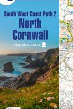
The A-Z Adventure Series of maps is the perfect companion for walkers, off-road cyclists, and anyone wishing to explore the great outdoors.
Navigate your way around Great Britain with this detailed and easy-to-use A-Z Road Atlas
Navigate your way around Great Britain with this detailed and easy-to-use A-Z Road Atlas
This full-colour road atlas features 30 pages of continuous road mapping. Includes Cornwall, Devon, Dorset, Plymouth Somerset and Torbay.
A full-colour regional road atlas featuring 39 pages of continuous road mapping. Covering an extensive area, including Bristol, Swindon, Reading, Slough, Guildford, Littlehampton, Portsmouth, Isle of Wight, Bournemouth, Cardiff, Newport, Weymouth, Sidmouth, Taunton and Weston-Super-Mare.
A pocket-sized paperback street atlas of Central London in full colour, covering an area extending from the centre of London to: Brent Cross, Golders Green, Highgate, Finsbury Park, Stoke Newington, Leytonstone, Wanstead, West Ham, Thames Flood Barrier, Eltham, Grove Park, Catford, Streatham, Wimbledon, Barnes Bridge, Willesden Junction, Neasden.
Navigate your way around Norwich with this detailed and easy-to-use A-Z Street Atlas.Printed in full-colour, paperback format, this atlas contains 42 pages of continuous street mapping. More than 4,500 streets indexed. Large scale 4 inches to 1 mile map.
Navigate your way around Glasgow with this detailed and easy-to-use A-Z Street Atlas. Printed in full-colour, paperback format, this atlas contains 168 pages of continuous street mapping.
Abonner på vårt nyhetsbrev og få rabatter og inspirasjon til din neste leseopplevelse.
Ved å abonnere godtar du vår personvernerklæring.